TONGARIRO ALPINE CROSSING
tongariro national park
North island, new zealand
March 22, 2008


TONGARIRO ALPINE CROSSING
tongariro national park
North island, new zealand
March 22, 2008

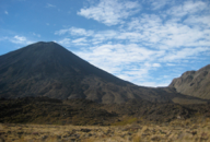
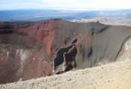
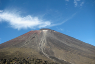
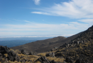
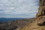
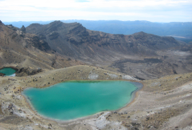
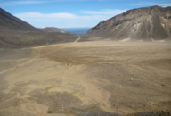
In 1887 the Paramount Chief of Tuwharetoa people, Te Heuheu Tukino IV, donated the mountain peaks of Tongariro, Ngauruhoe and Ruapehu to the nation of New Zealand. This gift laid the foundation for Tongariro National Park. It was the first gift of its kind ever made by an indigenous people. A World Heritage site, this park is the second largest of their parks, next to America’s Yellowstone Park. The Ketetahi Block, culturally significant Ketetahi Hot Springs, are contained within the land over which the hiking track passes, some 400 meters in length. The visitors are asked to respect this land, and not to trespass beyond the boundaries of the track. Henry and I were very excited about walking this track, an endurance walk of 18.5 kilometers (11.5 miles). To put it in New York City terms, this hike would have been the equivalent of working out for 4 1/2 hours on a treadmill plus 2 hours on a stair master, all in one day! The Tongariro Alpine Crossing is considered to be the BEST one-day alpine hike in all of New Zealand. To accomplish this, we signed up for a tour guided by the Tongariro Expeditions. They provided bus transportation, one and one-half hour each way, from Taupo to Tongariro National Park. Their guides guaranteed safe conditions and provided each hiker with a brochure and explicit instructions and guidelines for making the trek. The outfitter rented boots, poles, jackets, and sold bottled water to properly prepare the hikers for their adventure. Each trekker had to be accounted for at the end of the day. We signed a list and checked our names off that list at the end of the trek. If any name on the list was not checked off at the end of the day, expedition outfitter called for Search and Rescue helicopter flights, an expensive proposition. Beyond that, each person was “on their own” making their way, step by step, across amazing landscape and challenging terrain back to the bus for a pickup back to town, no later than 5 PM. We awoke at 5:15 AM in order to be outside our hotel for the shuttle bus pickup at 6:20 AM. The bus was practically full when we boarded for the dark, quiet ride to the mountains. It was cold upon arrival, approximately 8 degrees Celsius (46 degrees Fahrenheit). Clouds hung low over the mountains, and the heath and heather in the fields surrounding the mountains were waist high. The trek was advertised to take between 7-8 hours to complete. This being a holiday (Easter) weekend with clear, summer-like Autumn weather, there were massive numbers of people arriving to hike. Our company alone transported almost 200 hikers to the trailhead. My best guess is that at least 500-1000 people hiked the Tongariro Crossing that Saturday. The trail began at Mangatepopo car park, with an easy hike up the valley to “Soda Springs”, which was estimated to take about an hour. The next part of the track was called the “Devil’s Staircase”, an obvious name given to a steep rocky climb. The final portion of this was up many, many, many flights of wooden staircases that seemed to never end. This was the really grueling part of the hike, which carried us to the entry of the “South Crater”. We were able to take it a bit easier here as this area is dead flat. On the opposite side of this crater is the base of “Red Crater Ridge”, the final climb of the day, but by no means the end of the trek. At this point, smoke rose from various points in the crater, smelling of hydrogen sulfide. Here was our opportunity to make yet another steep half-hour climb to the top of the “Red Crater”. Things got a little dicey here. This section of the track is steep with drops off on either side. We were warned, by our expedition bus driver and with our written instructions, not to get too close to the edge. If we were to have fallen into the crater, we would NOT have come out. At this point, we passed some family groups leaving the mountain. Here was the point of no return. To go further required a commitment to finish; there was no backing out of the full trek. To make the task even more interesting, the steep surface on this area was of loose rock called “scree”. It was deep and dusty, requiring us to walk with the weight on our heels, or crab walk by side-stepping across this ridge of the mountain to avoid slipping into the crater! Most hikers managed this like skiers; however, we noticed a number of hikers who had to be talked down this portion. Once this maneuver was complete, Henry and I found a rock (resembling a Scott Burton sculptured chair) upon which we sat to eat our power bar snack and have some water while overlooking three “Emerald Lakes”. Even though we had been warned not to drink the water or enter the lakes, some uninformed hikers were wading in the pools! (We were told these pools contained nasty minerals; there was a reason they were green!) At the bottom of this trail we ended up in the “Central Crater” a flat, packed earth trail through a landscape strewn with volcanic lava rocks. After this, we walked and walked down what felt like hours of switchback zig-zagging trails through Alpine meadows overlooking the blue lakes, including the enormous Lake Taupo in the far distance. The landscape began to change as we descended the mountain, with grasses, heath and heather, and alpine flowers becoming enriched with greenery and shrubbery. Past the Ketatahi Hut, we continued down a descent with steps cut into the trail, some 18-24 inches (45-60 cm) high . This trail, with more steps, meandered into a temperate rain forest of ferns, mosses, fern trees, and conifers. It followed a clear, flowing stream with wooden foot bridges crossing the stream at two points. The dappled shade through the foliage was a cooling relief after hours in the blue sky and sunshine. Henry and I had no idea how long this portion of the trip would take us to complete. We just kept walking, worried that we might miss the last bus, even though it was only just after 2 PM. When the forest opened up to grass, with hikers lying on the lawn before a hut, we knew we had made the trek in good time. Instead of resting on the grass, we went, as instructed, directly to our bus, checking our names off the list as required. Much to our surprise, it turned out that we completed the entire Tongoriro Alpine Crossing in only 6 1/2 hours! The reward: being on the first bus back to Taupo, soaking in a muscle-relaxing jacuzzi, and having a good meal at the Edgewater Resort overlooking the lake. It was only Advil that allowed us to get a good night’s sleep so we could white water raft the following morning!
*Scenes from the movie, Lord of the Rings, was shot in this landscape.
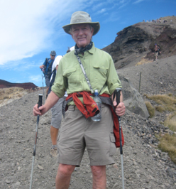
PHOTOS: Left Column: 1. Mangatepopo Valley at 8 AM. 2. Mangatepopo showing the saddle to Mt. Ngauruhoe. 3. View from the “Devil’s Staircase”. 4. View from the “South Crater”. Center Top: Henry in the “scree” at the “Red Crater”. Center Bottom: Jourdan at the South Crater with Mt. Ngauruhoe in the background. Right Column: 1. View into the Red Crater. 2. Mt. Ngauruhoe. 3. The”Emerald Lakes”. 4. The “Central Crater”.

Lord of the Rings Territory*