achnahaird bay walk
Achiltibuie, Wester Ross
Scotland, United Kingdom
british isles
September 5, 2010

achnahaird bay walk
Achiltibuie, Wester Ross
Scotland, United Kingdom
british isles

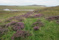
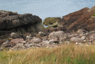
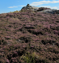
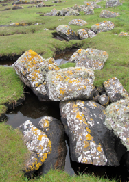
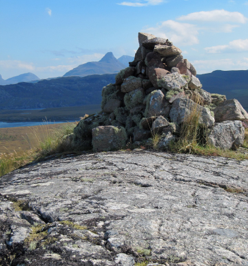
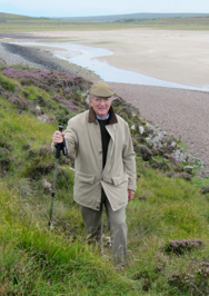
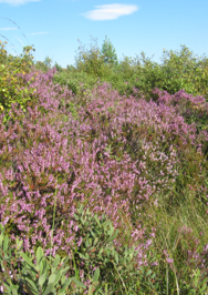
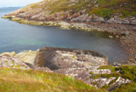
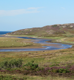
What Henry and I later referred to as the “Heather Walk” began on a hill above a flat, serpentine river that flowed into a bay ringed in cliffs and carpeted with white sand. This walk was our first personal encounter with the wilds of Scotland, where we learned about the illusion of topography and the deceiving nature of beauty. We chose our first walk, Walk #4, out of a total of 26 walks, each carefully described and placed in a binder at Summer Isle’s Hotel. The printed description we took with us began with a place to park the car: “near the point where the road forks beyond Lochs Vatachan and Raa”. The next direction suggested we then “walk a few hundred yards in the Ullapool direction and cut down to the river leading to Achnahaird Bay”. This first step on our walk struck me as somewhat bizarre because there was apparently no marked trail or path to follow. I plunged into the apparent grasses to find myself knee deep in heather and bog, not pleased with what I felt under foot. Fortunately, I had on my “wellingtons”. Henry joined me with similar grimace and we made our way toward the river. Once there, there going was easier, as the river’s edge was lush with moss and river rocks and large stones literally paved our way. As we neared the bay, it felt natural for us to climb higher on the hill through the grasses, and not venture toward the huge stone cliffs along the beach. This decision put us in interesting territory, not charted on our instructions. It also gave us a “birds eye” view of some beautiful landscape and seascape. We could also see the immense slabs of rock beneath us with the strong winds rippling the water of Achnahaird Bay. And looking across the bay, we could see the beautiful cliffs of Rubh’a’ Mor on the far side. Walking farther along, we could see the rocks of Rubh’a’Choin stretching dramatically into Enard Bay. Henry and I climbed to the highest point on this part of the landscape, toward a pile of stones called a cairn. From that point we could see, in the distance, the river flowing from Loch Garvie into Garvie Bay. As we surveyed the landscape before us, we could see what appeared to be a broad fire lane in a fairly new plantation of pine trees and deciduous trees. We had already climbed a stile into the fenced area, and needed to find our way to the other side, as well as meet the highway so we could return to our parked BMW. All practical matters considered, we didn’t expect to meet some impractical obstacles along the way. As we ventured down the hill, the ground beneath our feet became more moist, finally becoming wet and boggy. Not only was the ground spongy and oozing water, but the tree plantation was littered with waist-high heather, tall grasses and shrubs, and adolescent trees that towered over our heads. Most unnerving, deep holes also littered the field where tree stumps from older forests had been removed. Both of us realized that this random pattern of holes, each filled with water, could cause us injury if we were not very careful walking across this wide expanse. I walked ahead, simply because I was wearing boots that would allow me to step in water. Henry had a hiking pole and could feel ahead to detect irregular ground. Between the two of us, we made our way out of this “mine-field” unscathed. We learned that tall grasses concealed the deep holes, so we walked on the thick heather instead, trudging carefully a step at a time, and weighting only one foot at a time, just in case one leg fell into a hole. It was very slow going, requiring patience and keen observation. Finally the pockmarked field holes gave way to rivulets of bog that I simply slogged through in a straight line “home”. Henry’s hiking boots took a beating and his socks were soaked, but everything dried out overnight. The next morning his boots looking like new because of his encounter with the rough, tall grasses.
The trek was approximately 6.5 miles in distance, requiring 4 hours to complete.
PHOTOS: Left Column: 1. First steps into grasses, heather and bog as we cut down from the road to head for the river’s edge. 2. Henry traversing the hillside as we climbed above the river and the cliffs along the sea. 3. View of the rock slabs and cliffs beneath us. 4. View of the cliffs of Rubh’a’ Mor across the bay. 5. View of the rocks of Rubh’a’Choin stretching dramatically into Enard Bay. Center, Top: The beautiful heather covered landscape that encircled Achnahaird Bay. Center, Middle: Walk to the highest point in the landscape. Center, Bottom: The cairn at the top of the hill. Right Column: 1 The moss and grass covered riverbank with rivulets and large lichen covered rocks. 2. The encounter with trees, waist-high heather, shrubs and tall grasses that concealed treacherous holes filled with water. 3. View of Garvie Bay with the river flowing from Garvie Loch.

Through the Heather & Bog